Private Pilot Weather SIGMET what you need to know!
Kenny Keller and Brian Rutledge explain SIGMETs, the alerts pilots need for severe turbulence, icing, dust, volcanic ash, and thunderstorms. They cover when SIGMETs are issued, how to read them in text and graphic formats, and where to find them on aviationweather.gov.
Chapters
Hey, it's Kenny with Helicopter Land Ground School. Got a good video for you today and we're going to show you one of our new weather videos that Brian Rutledge, our operations manager, just completed and it's on Sigmetz. Okay. As a helicopter pilot, you have to understand Sigmet's. Have to be able to read them very important because you don't want to get yourself out there and get yourself into some bad weather and possibly lose your life. So Sigmet is a very important one for every pilot. Starting off as a student pilot all the way through cfi, all throughout your pilot career, you need to understand Sigmet's. So we're going to get to that presentation in just a minute. I'm Kenny Keller, creator of Helicopter of Online Ground School. Helicopter Online Ground School. I want to share two member checkride stories real fast. First one's from Germany. I freaking love this. I love hearing from people in the US But I also love hearing from people from other countries. This is from Alex and he said, hey, Kenny, I want to share with you or I want to share with all of you that I have passed my checkride today. I'm proud to say that because the process was very demanding and I want to thank all of you for the online support you give all of us. I'm happy that I've booked the lifelong membership because I'm aware how important it is. Important it is because I know that the license is only the paper that gives you the ability to to learn even more yourself. Best regards from Germany. I freaking love that. And he's a professional pilot member and that's pretty darn popular, right? Because you get all the training. Private, commercial cfi, instrument never expires. It's going to always be there for you. You can grab that down below. And then our next one is from Chris and Chris says, hey. Hi, Kenny. I want to let you know I successfully completed my IFR checkride yesterday. The Hogs program was a great supplement to my 141 program. So thanks for your awesome curriculum and instructors. Now on to my commercial course rating. Sincerely, Chris Cox. So congratulations, Chris. That is freaking awesome. And this is a great time to mention something new we got coming where you're going to be able to switch your memberships yourself. For example, if Chris wants to go now from instrument to commercial, you'll be able to do that. We're setting that up so it's coming probably within the next few days. We'll get that up and running. So instead of Having to unsubscribe and then sign back up or email us and have us do it. It's going to be a more simplified process to just switch. If you get your private done and want to go right to instrument, you're going to be able to do that yourself. So we're getting that all set up right now. So want to bring that up again. HelicopterGround.com links down below the video. You can check out all of our memberships there. So I'm going to roll that Sigma video for you now and we'll be back just shortly when it's done. It's about 18 minutes. But this is good content that you need. This is number 10 of 10 brand new videos inside helicopter on land ground school within the private pilot section. So let's roll that now.
Right. In the last lesson we went over airmet and all the various ones. Remember we talked about Airmet Sierra, Hermet Tango and Airmet Zulu. Today we're going to talk about sigmet. So what is a sigmet? Sigmet significant meteorological information. So that word significant at the very beginning should get your attention. This is very important area when you start talking about weather briefings and briefing for go no go decisions.
So.
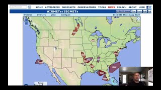
A sigmet is a concise description of the occurrence or expected. So if the forecaster believes that these certain types of weather phenomenon are expected to occur, then they'll go ahead and they'll put out a sigmet. So it's either it's already occurring or it's expected to occur and it's certain type of en route weather that may affect the safety of aircraft operations. Sigmet's they are issued in textual format as well as graphical. And you'll see on the Aviation Weather center website the graphical they're very similar to, well a little different than the way the air met is set up but still it's a graphical representation and this is to get the information, disseminate the information out to all pilots in flight so they can enhance safety. So it is a very, very important topic to discuss. They're issued as soon as practical. As soon as the forecaster has weather information that coincides with the criteria for a sigmet, then they're going to get that information out as quick as possible and it is potentially hazardous enroute weather conditions. So sigmet there is some standardization with sigmet. Just like in airmets, the altitudes themselves are going to be represented in MSL mean sea level unless otherwise noted. And then remember in the airmet section. We also talked about how they display the altitudes themselves and they're going to be expressed in hundreds of feet. So in this example, 030 would be 3,000ft. If the 3 was at the far right end at 003, then that'd be 300ft. Anything at or above 18,000ft will be expressed as flight level. So you'll see the FL in front. So this example is flight level 21,000. The text is prepared in that abbreviated plain language, very similar to the airmet. And remember they can use non abbreviated words, geographical names, numerical values that are self explanatory, 100% allowed and they make it that way so that the student pilot, the pilot that hasn't flown in a long time, you pull up a sigma, you should be able to read the textual portion rather easily. They want to make it as easy as possible. There are two types of sigmets you need to be aware of. Non convective and convective. And we'll get into each one of those separately. So non convective segments. There is an issuance criteria and here is the conditions for that. So any area or I'm sorry, if the following conditions that we're going to list out if they are affecting or expected to affect an area of at least 3,000 square miles. So again, a very, very big area that we're talking about or the forecaster, he or she believes that that area is going to have significant impact on the safety of aircraft operations. So what type of criteria are we talking about? Severe or greater turbulence. If you have seen the turbulence presentation, you'll remember that, that we talked about light, moderate, severe and extreme turbulence. So for a non convective segment to be issued on turbulence, it must be severe or greater. So severe or extreme icing. Severe icing. I don't believe I've done the. As a matter of fact, I know I haven't. I haven't put out the icing presentation yet. But in icing you've got trace, light, moderate and severe. So once it hits the severe level, a non convective sigmet would be issued. Widespread dust storms and widespread sandstorms and then volcanic ash. Off to the right of each one of these you see the abbreviated format that you would see if any of these conditions were in an actual segment. This is how they're going to abbreviate severe turbulence, severe ice and so on. Sigmet's non convective the issuance time and valid period. So they are unscheduled. There is no schedule as far as these go, they are issued when conditions meet the sigmet criteria. So for non convective, the slide prior to this, when we start talking about turbulence, icing and all those other things that were listed, as soon as those things start to, or the forecaster believes it's going to occur, that's when the sigmet will be issued. Conditions are occurring or expected to occur within a four hour period. Valid period can be up to but does not exceed four hours. And if the conditions are going to go past that four hour period, then the sigmet is reissued. Sigmet identification so in the want to call it contiguous United States, Continental US really doesn't matter the way they identify a sigmet in the textual format in the United States here it is, they're going to use the, the Alphabet and I'm not going to read all those, but you will see at the very end Sierra and Tango are excluded. And that's because the United States when we talk about Air Mets we use Sierra and Tango. So those are the ones that you would see from the contiguous United States. Then out over the ocean on the west coast we got the Oakland oceanic area. This is the abbreviate or I'm sorry, the identifiers for sigmet's in that area. Honolulu, this is what they use. And then in Anchorage, Alaska these are the India, Juliet, Kilo, Lima and Mike, that's how they're going to identify sigmet's in those areas. Okay, so here are the areas of responsibility, excuse me, in the continental US So you can see how it's broken down into, into sections for those particular sigmets. And here is the Atlantic Basin. Houston, you see on the bottom, Houston, Miami, Miami Oceanic, San Juan, the New York area over on the east coast. And here's the one for the west coast, this is the Oakland one we were talking about. So how, how does a sigmet look texturally? That's very similar to the Airmen. Similar I say. So here's one, this is out of the aviation weather book and if you notice on line 2 it says Sigmet Romeo 1. So this is an identifier that we just talked about. Depending on where the sigmet is actually located, which agency and their area of responsibility will indicate, you know, what, what name they're going to use. So Romeo1, if there was a additional sigmet after this would be Romeo 2 got the valid date and time there. So the 10th day of the month at 0530 hours and then the third line, Oregon and Washington. Again, the abbreviations that you should be able to decipher. And then I put the little reminder there. These are VOR identifiers. So if you were gonna map this out on a VFR sectional, you would just take those, those VORs that are listed, plot them out, you'd see the area that it covers. However, because the Aviation Weather center is so smart, they give us a graphical depiction, makes it a lot easier. Then down at the bottom you see severe turbulence between flight level 28,000 and flight level 35,000. And then says conditions continuing beyond 05:30 hours. Again, abbreviated plain English, easy to understand. Sigmet cancellations, amendments and corrections. So non convective sigmet cancels when the phenomenon stops occurring, is not expected to occur or it has moved out of the area of responsibility. So if it moved from, let's say we had thunderstorms that started off over in the, the west side. That previous picture that I showed you, it was United States and it showed all those different areas of responsibility. Well, if that line of thunderstorms moved out of one and moved into another, then the other area of responsibility, responsibility would issue a sigmet for that area. Amendments are not issued, but instead they give a new sigmet with a new series number and corrections. You'll see that COR that we talked about in the air Mets and it'll be located at the end of the first line right after the UTC date and time stamp that's on there. Convective segments. This is the other one. So we just talked about non convective. And now we're going to talk about convective convective segments. So convective segments. And we'll talk about the ones in the contiguous United States. They're issued for thunderstorms and imply severe or greater turbulence, severe icing and low level wind shear. The issuance criteria, when any of these following conditions are occurring, or again if the forecaster believes that they're expected to occur. So a line of Thunderstorms at least 60 miles long with those thunderstorms affecting at least 40% of its length, that's a pretty, pretty good sized area of line of thunderstorms. An area of active thunderstorms affecting 3,000 square miles and covering at least 40% of the area. And again they talk now they talk about radar intensity. So if the forecaster is getting a very strong radar return or the satellite imagery is showing very significant type weather for thunderstorms and then lightning signatures, then they're going to, they're going to issue a convective segment. Again, convection. If you don't remember what convection is, we're not going to go into that right now. Go back to the thunderstorm presentation and that'll clear it right up for you. Embedded or severe thunderstorms that are expected to occur for more than 30 minutes during the valid period, regardless of the size of the area. So embedded thunderstorms, it could be one, it could be many. Special issuance criteria. When do they do that? When any of the following has occurred. Or again, if the forecaster believes it's going to occur for more than 30 minutes. So tornadoes and then hail greater than 3/4 inch at the surface, because at altitude it could be a lot bigger, but at the surface it's three quarters of an inch. Wind gusts greater than or equal to 50 knots. That is some howling wind, and that's at the surface as well. The forecasters judgment they have indications that the weather is changing rapidly and they're not covered in an existing convective segment, then they'll issue a special. The special issuance is not required for a valid convective segment. So you could have a valid convective segment, but if anything changes from the original, maybe it was the line of thunderstorms, and now they have indications that there's a tornado or hail or the really strong winds of 50 knots at the surface, then they'll issue a special convective segment. Issuance time invalid period. So the convective segment bulletins again for the contiguous United States are for the Eastern, Central and Western regions. And it'll make more sense when I show you on the map. They're issued on a scheduled basis. Remember, the other ones were not scheduled. These are scheduled 55 minutes past the hour. Each bulletin contains all valid convective sigmettes within the region. And they're good for two hours or until the next. Hourly issuance bulletins must be transmitted each each hour for a region. And they do it because these are very, very important pieces of information they need to get out to pilots. We just talked about the weather conditions, the criteria for one. So it's really important that they get this information out. And that's why they do it this way. If the conditions do not meet or are not expected to meet that convective sigmet criteria at the scheduled time, then what will show up is convective sigmet. None. So in the previous slide, at the very beginning, I told you that it was the west, the Central and the Eastern regions. So this is how convective sigmet's areas of responsibilities work a little bit different compared to the non convective sigmet's area of responsibility. So you've got three areas, west, central and east. On aviationweathercenter.gov here is the graphical representation of sigmets. I know it says Air Met sigmettes at the top, but when I click if I select Air Mets, go back to the previous presentation and you'll see how those show up for turbulence, icing and IFR mountain obscuration. A little bit different. Anyways. Nonetheless, this is what it looks like on the graphical. And then if you click on one of the areas that are highlighted, it'll pop up. So here's the convective segment. You can see the top right corner of this box near the X that area graphically displayed. The color looks a little bit different. That tells you this is the one you're looking at. This is the textual information that aviationweather.gov will give you. And if we look down, down where it says convective Sigmet 59C. 59C. That is the sequential numbering of the sigmet for the day. It's the 59th one and it's C stands for Central. Remember, it's broken up into. Sorry about that, I turned my mic off. It's broken up into West Central and eastern areas. So if you see the C that tells you that is a central area of responsibility for the sigmet. Then it's got the the written text down at the bottom using abbreviated language. Here's what the textual looks like for that same area. And I highlighted the error. It says convective Sigmet 59C just so that I wouldn't forget to talk about it. But I did talk about it in the previous slide. So moot point. Anyways, this is the exact same information. However, there's a little bit more. You see down at the bottom. It says Outlook Valid. There'll always be an Outlook Valid in the full textual section on these sigmets in the slide prior. That gives you just a real quick glance at where this area is located and what the weather criteria or conditions that are occurring or expected to occur. But every fully written sigmet textual area will always have this outlook area down at the bottom. That's why it's important to look at the full textual section so you understand everything. Now out of the Aviation Weather Handbook, this is kind of their description of decoding an example of a convective segment. I wanted to put this in here because once you look at this and try and, you know, read through it, if there's anything you don't understand, go to the very next slide and there you go, it's all written out for you. It tells you exactly what that SIGMET is telling you. Cancellations, amendments and corrections, they're not cancelled, however, they are superseded by the next convective sigmet in the series. Amendments are not issued. Rather they give a new convective, SIGMUT is issued for that region. And as far as corrections, again, you'll see the abbreviated COR at the end of the first line after the issuance, date and time. Now, there is a lot of information out there for sigmet's outside of the US I didn't include that because this presentation would take forever. However, I thought it would be very helpful. If you want more information on that or you fly in an area outside of the U.S. i'm going to refer you to Advisory Circular. That's what the AC stands for.0045H and it's the 2016 edition. If you don't have it the hard copy, not a problem. All you have to do is go to faa.gov and you can put in that particular AC number and it will pull up the entire book for you free of charge online. Use it at your leisure. So that's everything about Sigmet's. Best way to get comfortable with them is go to the aviationweathercenter.gov website, go to the first tab for advisories, click on your airmets, click on your sigmet's, take a look at them and just start clicking on different areas. And here's the thing, if you pull up that map at the very beginning of a flight or a proposed flight for that day, you'll be able to see if there's any air mats or signets within the area that you're flying. This is a great go no go decision maker right at the very beginning and that's why they put it at the beginning of the tabs that you can click on when you're doing your weather briefing for self briefing because that's a, that's a sure way to do a no go is to click on something and, and have an air mat or a sigmet right in the area where you want to fly. You're done, you don't have to check anything else. You're done. So anyways, I encourage you to get on the aviation weather website a aviationweather.gov Excuse me, check it out. Play around with it and we'll see in the next lesson.
All right, awesome. Give us a like for the hard work Brian put into this. People have been enjoying the new videos from Brian. They've been commenting inside the site.
Wow.
Thanks, Brian, for breaking this down into a simple form and fashion that we can understand. The ones he's replacing I made five, six, seven years ago, right? Over time things change. Those were pretty dry and boring and they were really long. So in these, Brian has tried to really break it down to what you got to know and breaking it down and trying to explain it in a very simple fashion that the private pilot needs to be able to fly safely, of course, number one, but also to get through a checkride. So again, down below helicopterground.com there's private pilot, commercial pilot, instrument pilot, CFI, and then professional pilot where you get all the above. They're all explained down below and I'm going to throw out a code just because you've hung around to the end of the video. KK 25 off. KK 25 off. You can get 25% off the first month of any monthly membership. And you can also get 25% off that big professional pilot package. That's a great savings. You just take that code, KK25OFF, and you enter that code in the coupon box during checkout and then it will reveal that special discount, the price. All right? So do us a favor. Subscribe the channel. Click the bell so you'll be notified of our weekly videos. Subscribe to the channel. Give us a like comment below. We'll see you next video.
Peace out.