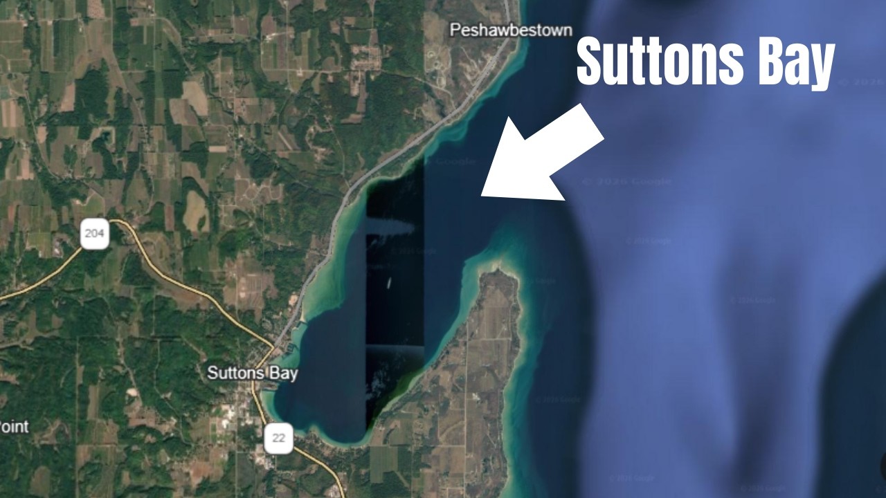
Sander Scott explains how Sutton's Bay, Michigan is built around its protected harbor, a bay-within-a-bay on the Leona Peninsula. The inward-curving shoreline and limited fetch make it reliably dockable year-round. The village's identity comes from this structural relationship to the harbor: a walkable downtown grid near the marina, mid-century neighborhoods, and later residential zones that respect earlier zoning and shoreline setbacks.
Chapters
Sutton's Bay, Michigan harbor structure, seasonal rhythm, and settlement pattern. Opening orientation: Sutton's Bay sits along the eastern shoreline of the Leona Peninsula facing the protected waters of Grand Traverse Bay. So Sutton's Bay sits within Grand Traverse Bay. It is a bay within a bay. It is often described as a harbor town, and that description is structural. The harbor is not simply an amenity, it is an organizing feature that the village of Sutton's Bay developed around. Understanding Sutton's Bay begins with understanding its water, harbor structure, and access pattern. Sutton's Bay functions as a protected harbor. It sits within the larger protection of Grand Traverse Bay, so it is a bay within a bay. Which buffers it from the full force of prevailing Lake Michigan weather patterns. Within that broader shelter, the shoreline of Sutton's Bay curves inward, further limiting direct wave exposure and reducing fetch. Fetch is the distance traveled by wind or waves over open water. So fetch is a key in determining the dockability, the ability to dock along a particular shoreline. That layer of protection allows for consistent marine activity, dock installation, and harbor-based infrastructure. The relationship to water varies across the village and township, but the structural distinction is geographic and not economic. There are properties with direct shoreline frontage, there are properties with elevated harbor views, There are properties within walking distance of the marina and public access, and obviously there are residential areas further inland where water access is secondary rather than immediate. Each location relates to the harbor and to Sutton's Bay differently. The harbor itself is active throughout the boating season and serves as both functional infrastructure and visual anchor for the community. Seasonal rhythm. Sutton's Bay operates on a pronounced seasonal cycle. During summer months, harbor activity increases, foot traffic expands along the waterfront, and downtown Sutton's Bay is fully active. In fall, activity tapers gradually, and winter brings quieter shoreline and reduced harbor movement. Obviously. Spring reintroduces gradual activity as navigation conditions improve. The water does not fundamentally change character between seasons. The pace around it does. Understanding Sutton's Bay requires recognizing that its visible intensity shifts while its structural conditions remain stable. Settlement pattern and property character. The built environment reflects successive periods of development. Historical structures near the downtown grid cluster close to the harbor, emphasizing walkability and maritime access. Mid-century neighborhoods extend outward along the shoreline and inland corridors. More recent construction tends to follow established residential zones rather than redefining the harbor core. Parking constraints, lot sizes, elevation changes, and shoreline setbacks all reflect the village's earlier settlement decisions. The street layout, commercial density, and residential proximity to the water are not arbitrary. They are outcomes of harbor orientation and shoreline geometry. Condominium presence and density. Sutton's Bay includes several condominium developments both along the shoreline and within the broader township area. These attached housing structures reflect a higher degree of density relative to other harbor villages on the Leona Peninsula. The presence of waterfront condominiums, marina-adjacent complexes, and inland attached units creates a housing form that differs structurally from places like Northport, where condominium opportunities are limited and detached housing remains the dominant pattern. This distinction is a function of zoning, shoreline configuration, and development history. What does not change about Sutton's Bay? Well, the curvature of the bay, its relative protection, the position of the marina, obviously the walkable grid near the waterfront, the These conditions define Sutton's Bay more than any seasonal fluctuation or short-term market behavior. The village exists where it does because the harbor functions reliably. That structural relationship predates tourism and continues to shape daily use. Sutton's Bay is not defined by activity levels alone. It is defined by its orientation protection, and settlement logic. Understanding that structure clarifies how the town operates over time. So quick interruption here and a plug for a book written by a local author and historian Kathy Firestone about Suttons Bay, Paushabitown, and Bingham Shores. This is a book you're going to want to check out if you're interested in Leonawee County and It's Shoreline.