Dr. Peter Heyman leads a National Frost Initiative project studying how extreme temperatures damage grain crops. The research tracks atmospheric drivers like polar air and inland winds, uses weather station data and crop models, and examines how clear nights and landscape drainage create frost conditions. August 2014 saw severe frost in southern Australia.
Chapters
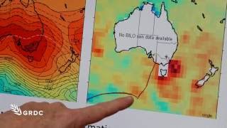
Understanding temperature extremes will lead to a better understanding of frost events. This is the core reasoning behind a National Frost Initiative project which is investigating the impact of extreme temperatures on grain. The research comes under the Initiative's Environment program, led by Dr. Peter Heyman. So the project that I'm working on with colleague James Risby from CSIRO and Hobart is really looking at these extreme events, these heat and frost extreme events, these spring heat spikes and frost events. It's these extremes of temperature that can be so devastating, as they tend to occur towards the end of a growing season when the money has been spent. Extreme heat events result from hot inland winds, while frost events are fueled by polar air. Not only is this air coming from a long way south, it's also coming from very high in the atmosphere and it's descending air. For that cascading, cold, dry air to develop into a frost event, there also needs to be a clear, still night, allowing the soil's radiated heat to disappear into space, leaving crops out in the cold. This complex mix of atmospheric conditions is usually, but not always associated with high pressure systems. With frost, we have this additional aspect of where you are in the landscape. So we have cold air flow. So cold air is a fluid that just flows in quite complex ways down the hill. So whereas a heat event, when it's hot, with a hot northerly wind, you tend to be hot everywhere, whereas frost is something that you can see a certain contour bank. Below a contour bank, there's a lot of frost damage and above it there's very little. So this cold air drainage is, if you like, a third process which further complicates frost. In late winter and early spring, when crops are at the critical flowering and grain fill stage, high pressure systems can straddle the continent. When these highs rapidly develop behind a cold front, a frost event can be triggered. August 2014, which was an extreme run of very, very bad frosts in southern Australia, was associated with these high pressure systems sitting much higher than normal. And so there are some ways to try and understand some of those processes. The research team is also making use of very accurate temperature data from a network of Bureau of Meteorology base stations to further analyse the relationship between extreme temperature and high pressure systems. As the highs pass each weather station, there's a huge advance in weather and climate science, and that's very apparent in short term weather. The problem with the short term weather information is that it will tell people there's a frost coming, but the information is very, very late in that regard. Gaining a better understanding of the climate drivers of frost and why some years are frostier than others could lead to forecasts of either the increased or decreased likelihood of frost. What the Extreme Temperature Project expects to deliver is robust frost and extreme heat Management strategies and, through crop modelling, help determine what varieties are best sown and when so as to minimise frost risk. For more information on Frost, go to GRDC's website.