Dr. Josef Kellndorfer mapped tree height, biomass, and carbon across U.S. forests by combining Space Shuttle radar data with Forest Service field plots. The resulting map identifies high-carbon regions in the Pacific Northwest, Appalachian forests, and Midwestern riverine systems for ecologists and land managers.
Chapters
Hi, I'm Joseph Kellendorfer. I'm a scientist here at the Woods Hole Research center, and I use satellite images and air photos to map the planet. This month's image is the result of a project that we just concluded in mapping the carbon stock and biomass in the forests of the United States. This map is a result of a project where we used very cool technology from the Space Shuttle radio topography mission. Together with field data which we collected in cooperation with the U.S. forest Service. The Space Shuttle radio topography mission gave us estimates of tree height. Very cool technology which we discovered. And by teaming up with the Forest Service, we were able to develop beautiful models that allow us to map heights and ultimately carbon and biomass in the forests of the United States at very fine detail.
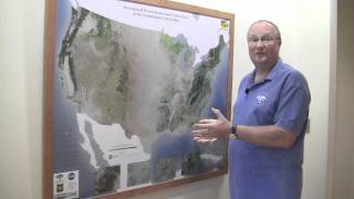
So here it is. Isn't it a pretty map? It actually shows nicely the distribution of our forests in the United States with respect to how much is where. That's what we were after. We wanted to have a nice map, nice depiction, a nice data set of, of how much forests we have where in the United States. It shows nicely the high carbon forests in the Pacific Northwest, the dense and intensive forests of the Appalachians, but also the forests of the Midwest, including the riverine systems. It's a good data set to have to know about our natural resource forests.
This map will provide ecologists and land managers with new and better information to support their work on biodiversity conservation, land management, wildlife risk assessment, timber management and production, while at the same time providing crucial information to scientists in understanding what role US Forests play in the global carbon cycle.